A place like Queensferry reveals its modern limits through lived familiarity—growing up through the Echline expansion and watching Ferrymuir change—set against planning files, council development plans, and transport studies that quietly define what could and could not happen.
Late twentieth- and early twenty-first-century interventions fixed Queensferry’s physical scale and civic role. It focuses on outcomes rather than events, tracing how infrastructure, zoning, and redevelopment decisions narrowed future options while locking the town into specific movement patterns, land uses, and planning constraints.
Visitor context: Stand where the old town meets the bridge roads, marina traffic and newer housing and modern Queensferry makes more sense. The town is still shaped by the same limits: water to the north, rising land behind, fixed bridge routes and only so much room to grow.
Governance, Planning Control, and Decision Lock-In
Post-war governance shifted Queensferry from incremental local change to externally driven planning control. Regional development frameworks increasingly treated the town as a managed edge settlement, prioritising containment over expansion and placing firm limits on industrial land, coastal alteration, and transport-led growth.
Planning policy removed earlier flexibility by formalising green belt boundaries south and west of the town. These designations constrained future housing and employment land, making later development dependent on infill or reuse rather than expansion, a condition that still governs planning decisions today.
The transition of the Hewlett-Packard site from advanced manufacturing to residential use reflected these pressures. Loss of employment zoning reduced local economic diversity, replacing it with housing that increased commuter dependence while permanently closing the option of reinstating large-scale industrial activity on that land.
Governance outcomes are visible in physical edges—ring roads, buffer zones, and zoning lines. Once fixed, these boundaries proved non-reversible, shaping how population growth occurred while limiting Queensferry’s capacity to respond independently to regional economic shifts.
Transport Infrastructure and Altered Movement Patterns
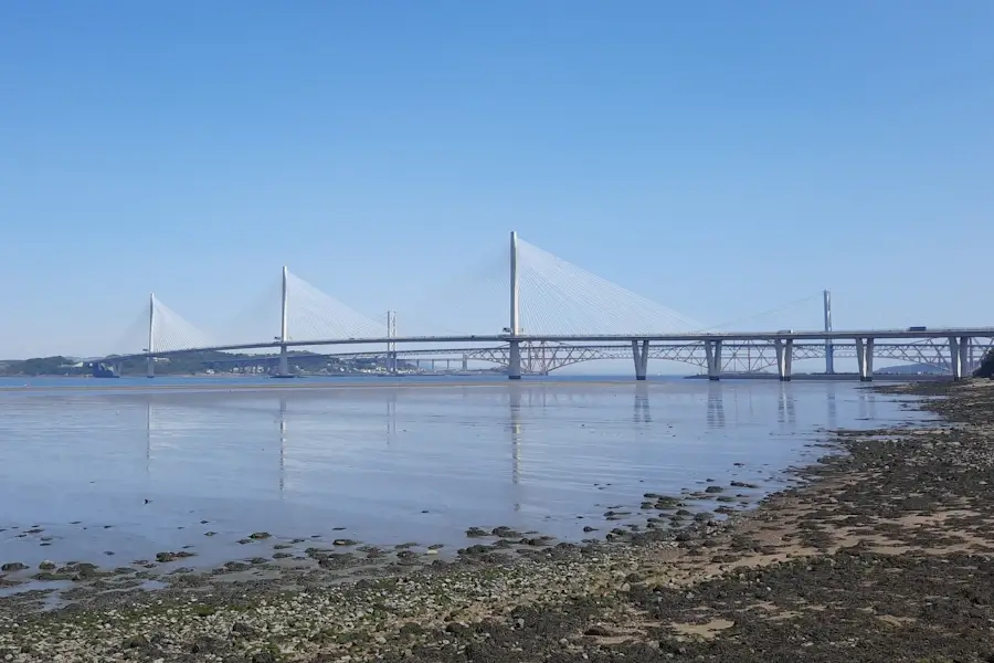
The Queensferry Crossing fundamentally changed how the town was approached, bypassed, and perceived. Designed for regional throughput, it shifted traffic away from local streets while reinforcing Queensferry’s role as a corridor rather than a destination within transport planning priorities.
This intervention removed any realistic prospect of reinstating ferry-scale or town-centred crossings as primary routes. Movement became elevated, faster, and detached from the settlement, reducing local influence over transport decisions while increasing exposure to infrastructure-driven constraints.
Policy decisions tied to the Crossing prioritised network resilience and capacity over local integration. Associated road layouts, slip roads, and exclusion zones fixed land use around junctions, limiting future development options and severing historic movement links within the town’s southern edges.
The result is a permanent spatial hierarchy: strategic traffic above, local circulation below. Once embedded, this structure constrained alternative transport models and reinforced Queensferry’s dependence on regional planning bodies rather than local transport adaptation.
Housing Expansion and Residential Saturation
Late twentieth-century housing growth around Echline and adjacent land followed a controlled-release model. Planning approvals responded to regional demand while deliberately limiting density and outward spread, ensuring residential expansion occurred without altering the town’s defined footprint.
This approach delivered housing but removed flexibility. Once estates were completed, the remaining surrounding land was protected or sterilised by policy, preventing future phased growth and locking the town into its existing residential scale.
Housing development replaced earlier mixed-use or agricultural land, eliminating transitional spaces that once allowed incremental change. The result was a sharper boundary between settlement and countryside, enforced through planning designations rather than natural limits.
Policy emphasis on residential character also constrained future employment or service-led development. Increased population without corresponding land allocation for industry or civic uses reinforced commuter patterns and reduced local economic autonomy.
Commercial Zoning and the Ferrymuir Concentration
Ferrymuir’s transformation into a retail, hospitality, and health services hub marked a decisive planning consolidation. Commercial activity was intentionally concentrated outside the historic core, relieving pressure on the High Street while permanently shifting service gravity southward. It’s where you’ll find Tesco, the Dakota Hotel and a new housing development.
The inclusion of NHS 111 headquarters embedded Ferrymuir as a strategic service node. This reinforced zoning decisions that favoured large-format development and parking-led access, removing the possibility of dispersed or small-scale commercial growth elsewhere.
Planning policy effectively traded flexibility for containment. While the High Street was protected from overdevelopment, it also lost the capacity to absorb significant new services, fixing its role as limited-scale retail and hospitality.
Ferrymuir’s boundaries are now defined by road layouts, service yards, and zoning edges. These features prevent functional reintegration with surrounding land, ensuring its role remains fixed and non-reversible within the wider settlement structure.
Land Reuse, Loss, and Non-Reversal
The redevelopment of the Hewlett-Packard site illustrates irreversible land-use change. Once cleared and rezoned, the site’s shift to housing removed specialised infrastructure, skilled employment space, and future adaptability for technology or manufacturing uses.
This loss was not accidental but policy-driven. Planning frameworks prioritised housing delivery over employment retention, reflecting regional pressures that outweighed local economic balance considerations.
Such decisions narrowed Queensferry’s functional diversity. Land capable of supporting varied uses was converted into single-purpose residential areas, reducing resilience and limiting responses to future economic change.
Physical indicators—street layouts, utility provision, and plot configuration—now prevent reversal. The built form enforces the policy choice, making alternative uses impractical regardless of future demand.
Visible Boundaries and the Fixed Town
Modern Queensferry is defined by visible limits: bypasses, green belt lines, retail zones, and residential edges. These boundaries are the physical expression of cumulative planning decisions rather than organic growth.
Each intervention removed options. Infrastructure severed older routes, zoning concentrated activity, and housing filled remaining gaps, leaving little undeveloped or flexible land within the town’s control.
Governance structures reinforced these outcomes by favouring predictability over adaptability. Once boundaries were agreed, they became reference points for all subsequent decisions, narrowing future planning debates.
The town now operates within a tightly drawn envelope. Change is possible only through minor adjustment, reuse, or intensification, not expansion or functional reinvention.
Queensferry is now structurally locked into a defined footprint, commuter-oriented movement patterns, and concentrated service zones. Future change must work around fixed infrastructure, planning boundaries, and irreversible land-use decisions rather than reshape them.
Conclusion
Much of Queensferry’s history explains events. What’s less often explained is how those decisions shaped the physical town you see now — the shoreline, the street levels, the late harbour, and the industrial scars. This shorter piece connects the history to the modern layout, without turning it into a tour.
Queensferry History Companion (Chapters)

A chapter-by-chapter historical reference
- Chapter 1 – Before Queensferry
- Chapter 2 – Early Crossings
- Chapter 3 – The Making of a Medieval Settlement
- Chapter 4 – Burgh Rights
- Chapter 5 – Turbulent Times
- Chapter 6 – 1700s Prosperity
- Chapter 7 – The Industrial Rise of The Ferry
- Chapter 8 – Steam, Railways, the Coming of the Bridges
- Chapter 9 – Queensferry in Wartime
- Chapter 10 – Modern Queensferry