South Queensferry: A Local Guide to the Waterfront Town
Most visitors arrive, photograph the Rail Bridge, walk the High Street, and leave thinking they’ve seen the place. They’ve missed most of it.
This guide is for the ones who want to understand what they’re looking at — why the street steps instead of running flat, what the red brick buildings on The Loan are doing in a stone town, and what the flat ground by the shore actually is.

Queensferry Walking Tour
Explore the High Street at your own pace with a simple route starting right from Hawes Pier. Perfect for cruise visitors and first-time visitors.

Things to Do in South Queensferry
Find the best viewpoints, hidden lanes, cafés, and easy coastal spots to explore around town – ideal for a quick visit or a full day out.

Best Places to Eat in South Queensferry
Looking for somewhere good to eat after arriving at Hawes Pier? This local guide covers the best restaurants, pubs, and cafés in South Queensferry—from quick lunches to proper sit-down meals with bridge views.

Near Queensferry
Discover standout attractions just beyond the town—Hopetoun House, Inchcolm Island, coastal villages, and hidden Forth-side gems within easy reach.

Queensferry Viewpoints: Best Bridge Photo Spots
Find the top places to capture the Forth Rail Bridge, from shoreline angles to quiet hill viewpoints most visitors miss.

South Queensferry: The Details You Notice Too Late
The quiet details most visitors never get explained. The harbour’s real purpose. The strange terraces. The whisky buildings on the Loan. Short, sharp context that makes the town click after the fact.
South Queensferry and the Bridges
Most places have one landmark. South Queensferry has three, and they’re stacked across the same stretch of water in a 127-year span of engineering history.
The Forth Rail Bridge – the red one, the UNESCO World Heritage Site – opened in 1890 and is still in daily use.
The Forth Road Bridge, the suspension bridge beside it, opened in 1964 and now carries buses, cyclists, and pedestrians after losing its car traffic to the Queensferry Crossing in 2017.
That third bridge – the cable-stayed one to the west – is the longest three-tower cable-stayed bridge in the world, which is the kind of fact that sounds made up until you’re standing underneath it.
What the town does particularly well is give you proximity to something vast. From the pier, the cantilevers of the Rail Bridge extend directly overhead – close enough that you can hear the trains. That contrast – small working town, enormous Victorian infrastructure – is what most visitors come for, and it holds up in person better than most things promised on a postcard.
The Town You’re Walking Through
South Queensferry is compact enough to cover in an afternoon, but what makes it interesting isn’t obvious from the surface. The High Street looks old and charming. That’s the misread. It’s a working merchant spine from the 1700s that never stopped doing its job. The steps aren’t decorative. The closes aren’t picturesque shortcuts. The brick buildings on The Loan don’t belong to the same story as everything else. Here’s what you’re actually looking at.
The Binks — Where the Town Actually Starts
The flat stretch of ground by the shore — below Hawes Pier, to the west — is where Queensferry begins. Not the High Street. Not the pier itself. This is the Binks: the landing point where boats grounded, goods moved, and Queen Margaret crossed the Forth in the 1070s on her way to Dunfermline. The town grew upward from here, scrambling up the slope behind. Once you know that, the awkward angles and uneven levels stop looking quaint. They start looking inevitable.
→ Why the town looks the way it does
The High Street — Working, Not Quaint
The stepped terraces on the High Street weren’t built for effect. The ground rises fast from the shore and 18th-century builders worked around it — negotiating rock, slope and loading access rather than imposing a tidy line. Ground floors were warehouses and storage yards. Upper floors were merchant houses. The closes between the terraces follow the lines of the original land plots, worn down over centuries of carts moving between the harbour and the upper town. The cafés and boutiques are doing exactly what these buildings always did: serving whoever’s passing through.
→ Merchants, trade and the 1700s High Street
The Tolbooth — The Town’s Pressure Point
The 1636 Tolbooth sits at the foot of the High Street for a deliberate reason. Close enough to the shore to control trade. Close enough to the street to watch movement through the town. Time was kept here. Weights were checked here. Disputes were settled here. Nothing important moved through Queensferry without passing close by. Most visitors walk past it. It’s worth stopping.
The Loan — Why the Brick Looks Wrong
Walk up The Loan and the building materials change. Stone gives way to red brick — and in a town built otherwise entirely of stone, that signals something. Vat 69 whisky blending and bottling operated here through most of the 20th century, bringing industrial scale and external money to a place that was never built around either. The whisky moved on. The brick stayed. What’s there now is a Scotmid, a GP surgery, and a charity shop. The buildings remain because they don’t go anywhere.
→ Why Queensferry looks the way it does
Port Edgar — Naval History Behind the Marina
Port Edgar sits slightly apart from the town and always has. It expanded through WWI and WWII as a Royal Navy base — destroyers, patrol vessels, fuel supplies, quick access to the Firth. The basins, quays and red-brick hangars are still there, now repurposed for leisure boats and Scotts Bar. Repurposed, not reinvented. That’s why it still feels slightly separate from Queensferry: useful, active, but never quite absorbed back into the town’s everyday life.
The Name and the Crossing
South Queensferry takes its name from Queen Margaret of Scotland, who established a free ferry crossing at the Binks in the 1070s for pilgrims travelling to St Andrews. The settlement that grew around the crossing point became known as the Queen’s Ferry. The “South” was added later to distinguish it from North Queensferry on the opposite bank of the Forth.
The ferry ran for nearly nine centuries. It ended in 1964 when the Forth Road Bridge opened. By then, Queensferry had already outlasted its original reason for existing — and kept going anyway.
→ The full history of Queensferry
South Queensferry Visitor FAQ
Why is it called Queensferry?
Queen Margaret of Scotland established a free ferry crossing here in the 1070s for pilgrims travelling to St Andrews. The settlement that formed around the crossing took her name.
“South” was added later to distinguish it from North Queensferry on the opposite bank of the Forth.
Why does the High Street have steps and terraces?
The ground rises sharply from the shore, and 18th-century builders worked around the gradient rather than against it. Storage, access, and trade shaped the layout.
The terraced effect is a practical response to uneven ground, not a decorative flourish. Many ground-floor spaces began life as warehouses, not shops.
What is the Black Castle on the High Street?
Black Castle is a 17th-century merchant house on the East Terrace. Despite the name, it was never a castle.
The name most likely comes from the dark stone used in its construction. It remains one of the clearest examples of the merchant architecture that shaped South Queensferry High Street.
What is the Tolbooth?
The Tolbooth is a 1636 building at the foot of the High Street. It served as Queensferry’s centre of authority, regulating trade, checking weights, settling disputes, and keeping time.
Its position near the shore path and High Street was no accident. In the old burgh, very little moved through town without passing close by.
What are the closes in South Queensferry?
The closes are the narrow lanes running between and behind the buildings on the High Street.
They follow the lines of the original land plots: long, narrow strips used by merchant families for storage, workshops, and harbour access. Many routes have barely changed since the 1700s.
What was Vat 69 in South Queensferry?
Vat 69 was a Scotch whisky blending and bottling operation based on The Loan. It brought industrial-scale employment to South Queensferry through much of the 20th century.
Its red-brick buildings still look slightly out of place in a mostly stone-built town. The main warehouse now houses Scotmid, a GP surgery, and a charity shop.
Latest South Queensferry Guides & Local Insights
New and recently updated guides covering viewpoints, walking routes, food spots and the small details visitors often miss. If you’re planning time ashore, these articles go deeper than the overview pages above.
Where to Eat With the Forth Bridges in View: South Queensferry's Best Tables
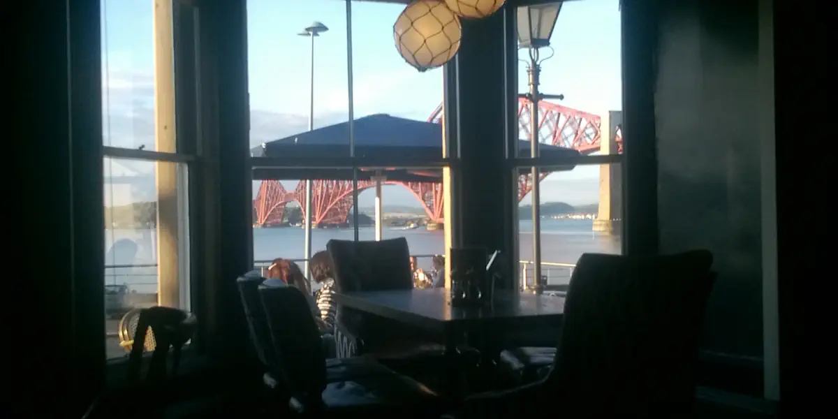
Many restaurants in South Queensferry describe themselves as a “restaurant with a view”. Some do. Some have outdoor seating facing the Firth of Forth, others facing a car park. A window seat at the wrong…
Walk the Forth Road Bridge: The Smarter Way to Do It
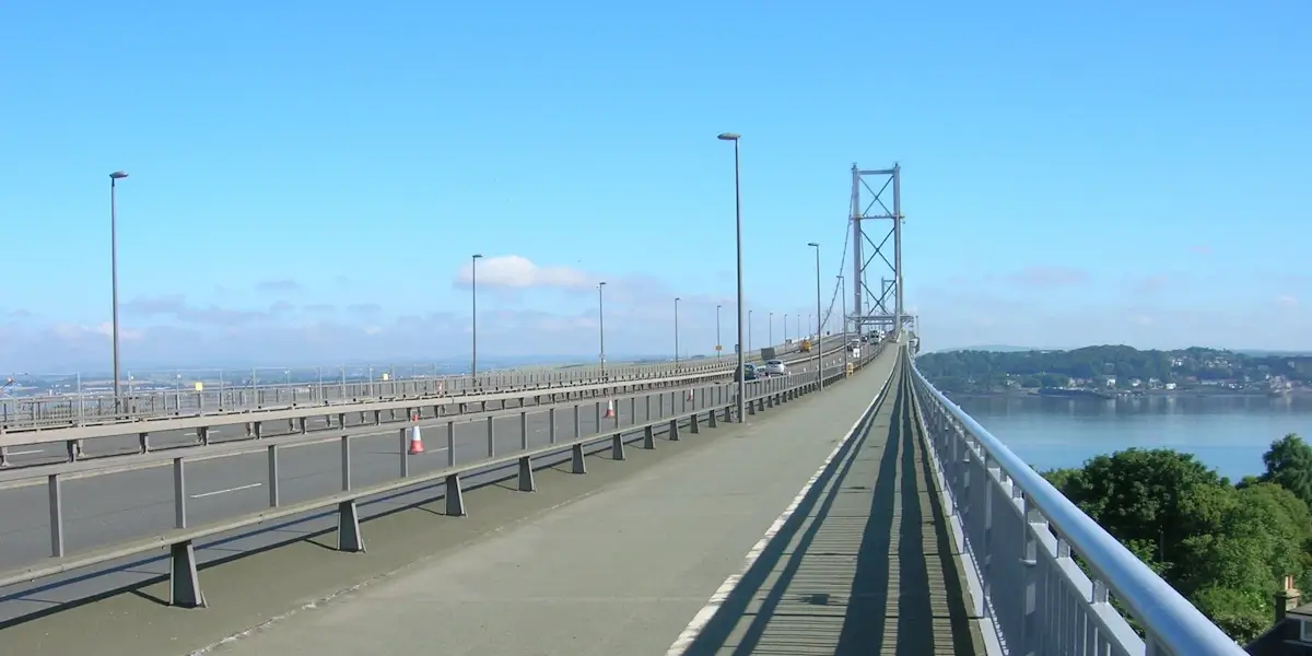
Want to walk across the Forth Road Bridge? Good choice if the weather is behaving on your day out in South Queensferry. Most guides explain the boring version. Walk the length of the road bridge…
Inchcolm Island from South Queensferry: The Smarter Cruise Day?
Inchcolm Island is one of the easiest shore excursions from South Queensferry, especially if your cruise tender lands at Hawes Pier. Instead of joining the coach traffic into Edinburgh, you can be on the water…
Shore Excursions from South Queensferry If You've Already Done Edinburgh

Most shore excursions from South Queensferry push you straight into Edinburgh. You step off the tender at Hawes Pier, look up at the Forth Railway Bridge, and head straight for the Old Town, the castle,…