
This post may contain affiliate links. If you book through them, I may earn a small commission at no extra cost to you. I only recommend personally curated options that make sense for cruise passengers and independent travellers.
People arrive in South Queensferry and feel it straight away – something’s different. Streets step instead of flattening. Buildings don’t quite match. There’s a Black Castle that isn’t a castle. The shoreline feels older than the town above it. A huge overthought railway bridge dominates the skyline. People park their cars in a spot where a Scottish queen sailed by ferry in the 11th century.
Table of Contents
If Queensferry has ever felt like a collision of 17th-century stone, 18th-century confidence, and mid-20th-century compromise, that’s not your imagination.
South Queensferry: A Timeline
Margaret, Queen of Scotland, establishes a free ferry crossing at the Binks for pilgrims heading to St Andrews. The town takes its name from her. The crossing point — not the High Street — is where Queensferry starts.
The Tolbooth is erected at the foot of what becomes the High Street, serving as the town’s centre of authority — trade regulation, timekeeping, dispute resolution. Everything that moved through Queensferry answered to it.
For centuries, boats simply grounded on shore. The proper harbour came later than most assume — infrastructure following function, not the other way round. When it finally appeared, it was an admission the old rough-and-ready method had hit its limit.
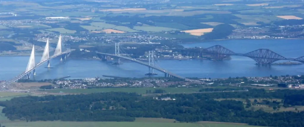
The railway bridge that still dominates the skyline opens after seven years of construction and the loss of 98 workers’ lives. The ferry that gave Queensferry its name gradually loses its purpose.
The Vat 69 whisky blending and bottling plant dominates The Loan, bringing industry and red-brick buildings to a stone town. Port Edgar — expanded in WWI and heavily used in WWII as a Royal Navy base — handles destroyers and patrol vessels, not pleasure boats.
The ferry crossing finally ends after nearly nine centuries. The Royal Burgh of Queensferry is absorbed into Edinburgh District in 1975.
The third bridge across the Forth at this point — and the largest three-tower cable-stayed bridge in the world — opens to traffic in September 2017, replacing the ageing Forth Road Bridge as the main road crossing.
Naval vessels replaced by leisure boats at Port Edgar. The Vat 69 warehouse is now a Scotmid, a GP surgery, a charity shop. The Forth Bridge is a UNESCO World Heritage Site. Queensferry remains a town shaped by every century that passed through it — and it still shows.
The thing is, most visitors to The Ferry do the same thing. On the Queensferry walking tour, they photograph a narrow lane, post the High Street because it looks “old and interesting”, then fill their social media feed with ten angles of the Forth Bridge. But they move on without asking a single question. They’ve never stopped to think “why?”. They’ve missed the point of Queensferry entirely.
The Town Started Here – Not Where You’d Expect
The Binks is the flat stretch of ground by the shore where Queensferry actually begins. Not the High Street. Not Hawes Pier. Not the buildings people photograph. This bit of level ground mattered first – boats needed somewhere forgiving to land, load, wait, and leave again in the 11th century.
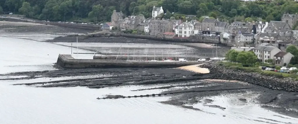
Before the stone frontages and the terraced High Street, this was the working edge of an ancient settlement. Ferry traffic. Goods. Animals. People moving north on religious pilgrimages. This is where Queen Margaret crossed on her way to Dunfermline Abbey and St Andrews – the crossing that gave Queensferry its name.
Most visitors instinctively start at the High Street and read downhill. That’s the mistake. Queensferry didn’t grow neatly from a centre. It formed at the waterline, around the queen’s crossing, then scrambled upwards. Once you see that, the odd levels and awkward angles stop looking quaint. They start looking inevitable.
This Is Where He Seemed Like One Man – And Became Another
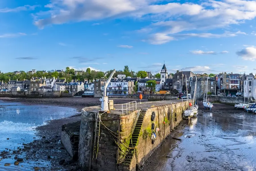
You can still put yourself right inside the novel Kidnapped. Sit with a pint in the Hawes Inn, mentioned in Robert Louis Stevenson’s famous novel. Then step outside and look down towards the shore. You’re standing where judgement once felt easy.

Walk to the water’s edge, and the emotions sharpen. This is the pier where Captain Hoseason took David Balfour aboard. No towering bridge then. No iron grid dominating the sky. Just water narrowing, boats waiting, and a man who looked respectable enough on land. That was the mistake.
As Stevenson wrote in Kidnapped:
They have built a pier for the service of the Ferry; and at the end of the pier, on the other side of the road, and backed against a pretty garden of holly-trees and hawthorns, I could see the building which they called the Hawes Inn. The town of Queensferry lies farther west, and the neighbourhood of the inn looked pretty lonely at that time of day, for the boat had just gone north with passengers.
That’s what this place does. It lets things appear settled right up until the moment they aren’t. The shoreline here wasn’t about scenery. It was about commitment. Once you stepped off the stone and onto a boat, the version of events you thought you understood could change completely. That tension still hangs here, even if most people never stop long enough to feel it.
Most people agree that the area around the Hawes Inn is one of the best Queensferry viewpoints to capture all three bridges and get close up to the Forth Railway Bridge.
This Part Came Much Later Than You Think
The harbour at South Queensferry feels part of the town’s original infrastructure – it wasn’t. For centuries, there was no proper harbour here at all. At the start, boats nudged onto shore and hauled off again. It was how the town operated and became an important seaport.
Records show that there was some kind of structure in the 18th century, but the present harbour dates from the 19th century. The stone walls defined its edges and changed the town into a working port, able to deal with tides, weather and demand.
This fact wasn’t inevitable in the town – it explains its shape. Queensferry didn’t wait for infrastructure before it functioned. Order followed necessity, not the other way round. When the harbour finally appeared, it wasn’t the beginning of the story. It was an admission that the old way – flexible, rough, and exposed – could no longer keep up.
The Street That Refused to Behave
South Queensferry’s High Street is like none other in Scotland. It climbs, drops, and breaks itself into steps – not for tourist interest – but because it had to. The ground here rises fast from the shore, and the street was forced to negotiate rock, slope, and access rather than impose a tidy line.

Those terraces weren’t about looks or about architects trying to do something different. They were working solutions. Storage below. Living space above. Doors and cellars cut to suit loading, not symmetry. The street is doing a job, even now, and it never pretended otherwise.
People describe the High Street as quaint. That’s the misread. The shops and bakeries at ground level were once warehouses. The buildings above are merchant houses and tenements.
This isn’t a street showing off age; it’s a street showing its working. Once you understand that, the uneven levels no longer feel awkward. They feel honest. The High Street isn’t misbehaving at all. It’s doing exactly what it was built to do, and it never learned to apologise for it.
Despite not being a long street, there are plenty of things to do in Queensferry – cafes, restaurants, bakeries, boutiques, and gin tasting.
These Buildings Don’t Match – And That’s the Clue
Live in South Queensferry in the ’70s and ’80s, and one name dominated – Vat 69. Now, all that’s left are the red brick buildings on The Loan that seem out of place. In a town built by stone and shaped by the ferry, brick signals something else entirely – industry, speed, efficiency.
Walk up The Loan, and you’ll still see the administrative buildings of the whisky blending and bottling plant. But the 6-storey warehouse is now home to Scotmid, a charity shop, takeaway, and a GP medical practice. Changed times with a subtle nod to the whisky industry in the town.
That’s why the buildings on the Loan still feel slightly off. They record a moment when Queensferry dipped its fingers into industrial scale and external demand — things the Ferry was never built around. The industry moved on. The structures stayed. What’s left isn’t charm or character; it’s evidence of a town briefly tilting away from itself and never fully correcting.
This Corner Still Divides Opinion
Stand at the foot of The Loan, and it’s hard not to start a sentence with, “What the…” In one frame, you’ve got the 17th-century Tolbooth, 18th-century buildings on the High Street, and Plewlands House behind. Then you look at the monstrosity of the 1960s block that marks the start of the High Street.

The inscription above the entrance to Plewlands House reads, “Christ is my Hope”, and many Queensferry residents have hoped that divine intervention would resolve the corner of The Loan. The materials are wrong. The tone is wrong. It doesn’t argue with the town – it ignores it.
That’s why people still bristle here. This corner exposes how fragile Queensferry’s balance really is. One bad decision, dropped into the wrong place, and the whole thing winces. No plaque will smooth it over. No amount of time will fix it – after all, it’s a place that many Ferry residents call home. It just sits there, beside centuries of careful survival, quietly daring you not to notice.
This Spot Decided More Than You’d Guess
The Tolbooth wasn’t put at the start of the High Street by accident. This was the point where authority needed to be seen and felt. Close enough to the shore to control trade. Close enough to the High Street to keep an eye on people. If you wanted order, this is where you planted it.

Time was kept here. Weights were checked here. Disputes were settled here. The town didn’t just pass through this spot – it answered to it. You could arrive by boat, haul goods up from the shore, and still end up under its gaze. Nothing important moved without passing close by.
That’s what most people miss. This wasn’t a picturesque leftover. It was a pressure point. The place where Queensferry decided who had permission, who didn’t, and on what terms. Stand here long enough, and it stops feeling decorative. It starts feeling supervisory – like the town still remembers being watched.
This Part of Queensferry Never Quite Joined In
The thing locals and visitors rarely realise is that the High Street was never meant to feel like the rest of Queensferry. Locals live in well-appointed housing estates – Echline, Scotstoun, Springfield, Varney, Linn Mill – but the High Street is different. Living in Queensferry and going ‘doon the Ferry’ were never the same thing.
Locals know what I’m talking about, tourists are happy to stroll the High Street with its quirky lanes, terraces, and buildings. But, that’s what Queensferry is.
That split only widened as the town expanded. Ferrymuir, Dakota, Echline, and the Tesco end of town grew outwards, practical and self-contained, built for modern life rather than spectacle. The centre of gravity shifted, but the High Street didn’t move with it. It stayed put, doing the same job it always had – a place you visit, not a place that carries the weight of everyday living.
This Quiet Edge Once Had a Very Different Role
Standing down at Port Edgar today, it feels like standing in a purpose-built marina. Boats bobbing. People coming and going. Scotts Bar & Restaurant – always popular with locals. It’s easy to assume it’s always been like this – calm, marginal, slightly detached from the town.
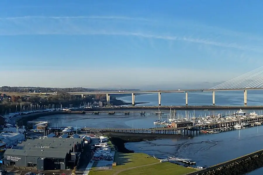
But look at the red-brick building and hangars – they tell a different story. Port Edgar never existed as a haven for pleasure boats. It had a vital job to do.
It expanded in the early 20th century and was heavily used by the Royal Navy, particularly during the First and Second World Wars. Destroyers, patrol vessels, fuel supplies, and support craft operated from here, taking advantage of deep water and quick access to the Forth. This was infrastructure, not scenery.
Today, the work has changed but the layout hasn’t. The basins, quays, and buildings are still doing what they were designed for — just at a gentler pace. Leisure boats have replaced naval vessels. The bar has taken over where orders once mattered.
Port Edgar hasn’t been reinvented; it’s been repurposed. That’s why it still feels slightly apart from the town — useful, active, but never quite absorbed back into everyday Queensferry life.
South Queensferry History FAQs
What is the history of South Queensferry?
South Queensferry’s history begins in the 1070s when Queen Margaret of Scotland established a free ferry crossing at the Binks — the flat shoreline below the High Street — for pilgrims travelling to St Andrews.
The town grew upward from that crossing point. Key landmarks include the 1636 Tolbooth, the 1890 Forth Bridge, Port Edgar’s Royal Navy years, the Vat 69 whisky era, and the end of the passenger ferry in 1964 when the Forth Road Bridge opened.
Today, the stepped High Street, mixed architecture, and harbour layout still show those layers clearly.
Why is Queensferry called Queensferry?
Queensferry takes its name from Queen Margaret of Scotland, who established a free ferry service across the Firth of Forth in the 1070s.
The crossing was mainly used by pilgrims travelling to the shrine of St Andrew in Fife. The town that grew around the ferry landing became known as the Queen’s Ferry, later shortened to Queensferry.
The “South” prefix was added to distinguish it from North Queensferry on the opposite bank of the Forth.
What is the Tolbooth in South Queensferry?
The Tolbooth in South Queensferry is a 17th-century building at the foot of the High Street, built in 1636.
It served as the town’s centre of authority, regulating trade, keeping official time, checking weights, and settling disputes.
Its position at the junction of the shore path and High Street was deliberate. Anything arriving by boat or moving through the town passed close by. It still stands today and remains one of the High Street’s most important historic buildings.
What was Vat 69 in South Queensferry?
Vat 69 was a Scotch whisky blending and bottling operation based on The Loan in South Queensferry.
The distinctive red-brick buildings it left behind stand out in a town otherwise built largely of stone. Several remain in use today, including buildings now used by Scotmid, a GP surgery, and a charity shop.
The Vat 69 era brought industrial-scale employment to South Queensferry through much of the 20th century before operations eventually ceased.
Photo attributions:
Tolbooth picture: Gpwitteveen, CC BY-SA 3.0 via Wikimedia Commons.
Binks image: Colin Dixon, CC BY-SA 2.0 via Wikimedia Commons.
Queensferry from the air: M J Richardson, CC BY-SA 2.0

Scott Gibson grew up in South Queensferry and runs queensferry.net. The Forth and Edinburgh guides come from lived experience — tender days at Hawes Pier, cruise traffic, the shortcuts into the city. For the wider Scotland cruise ports, he draws on friends in some of the port towns alongside port, operator and transport sources — so the detail holds up on the ground, not just on paper. Clear directions, real timings, no brochure fluff.