
This post may contain affiliate links. If you book through them, I may earn a small commission at no extra cost to you. I only recommend personally curated options that make sense for cruise passengers and independent travellers.
Planning to follow in the footsteps of Jamie and Claire in Cranesmuir on a Culross Outlander walk? Many guides simply list filming locations without explaining how to walk them. You end up circling cobbled streets, passing Mercat Cross several times, and wondering what you’ve missed.
Table of Contents
- Where Is Cranesmuir in Real Life?
- How Long Does the Cranesmuir Walk Take?
- Walking Cranesmuir – A Structured Loop
- Start Culross Outlander Walk at Admiral Cochrane’s Memorial
- Culross Palace & Gardens (Cranesmuir Square)
- The Hanging Gardens (Behind the Palace)
- West Kirk (Optional Detour)
- Lockit Well
- Culross Abbey
- Tanhouse Brae to Mercat Cross
- Mercat Cross
- The Causeways: Walking the Original Street Pattern
- Culross Town House – End of Cranesmuir Walking Tour
- Culross Harbour & Pier – Beyond Cranesmuir
- Best Time to Walk Cranesmuir (Culross)
- Getting to Culross (Quick Practical Notes)
- Visiting Culross from South Queensferry on a Cruise
- Is the Cranesmuir Walk Worth It?
- Cranesmuir (Culross): FAQs
The thing is, get this wrong and you waste precious time. Maybe you’re on a shore excursion on a cruise to Edinburgh, staying locally in Fife or South Queensferry, or just passing through on your way north. Without a proper guide, you double back, miss key angles, and the village feels smaller than it should.
This guide is about the route — where to start, how the streets connect, and how to get through the village without doubling back. For the filming background — which scenes were shot where and why Culross was chosen as Cranesmuir — that’s covered in the full filming location guid
A proper Culross Outlander walking tour isn’t about hunting scenes. That’s why this guided walk around Culross is structured around movement, not trivia. Start at the palace, descend through Tanhouse Brae, climb toward the abbey, and finish on the jetty in the Firth of Forth. It’s a clean loop with clear timing and local perspective built in.
Where Is Cranesmuir Filmed in Culross?

Cranesmuir scenes in Outlander were filmed around Mercat Cross, Culross Palace and the steep lanes nearby. These locations form the core loop of this Culross Outlander walking route.
If you’re looking for the full background on why Culross became Cranesmuir, see the detailed guide to the Outlander filming location.
How Long Does the Cranesmuir Walk Take?
A relaxed Cranesmuir walk in Culross with stops to take pictures takes around 60–90 minutes at an easy pace. That covers the palace courtyard, Mercat Cross, hidden lanes, and the climb toward the abbey. Add coffee or photo stops, and you’re closer to two hours. The cobbles aren’t flat – factor that in.
Walking Cranesmuir – A Structured Loop
Most Culross Outlander walk guides jump straight into filming trivia. They point at the palace, mention a scene, and move on. The problem is you’re left standing in the square, unsure which way to turn or how the streets actually connect.
Follow that approach and the village feels smaller than it should. You double back along Tanhouse Brae, miss the climb behind the palace, and reach the harbour without understanding how Cranesmuir fits together. It becomes a checklist, not a walk.
Here’s the cleaner way to do it. This structured loop starts with orientation at the Palace, climbs early, sweeps past the abbey and hidden wells, then returns through the square before finishing by the water. It’s deliberate, time-aware, and grounded in how Culross actually works.
Start Outlander Walk at Admiral Cochrane’s Memorial

Start beside the stone memorial in front of Culross Palace. Admiral Thomas Cochrane was born here in 1775 – a naval commander and political reformer whose career stretched far beyond this small Fife village.
From this point, you get a full, unobstructed view of the place every Outlander fan recognises – Castle Leoch – Culross Palace.
Culross Palace (Cranesmuir Square)
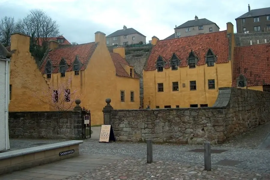
Culross Palace courtyard was used extensively as Cranesmuir’s village square in Outlander, particularly in Season 1. The ochre-coloured walls, crow-stepped gables and enclosed courtyard form the backdrop for several exterior village scenes involving Geillis Duncan and gatherings in the square.
Production relied heavily on the courtyard’s preserved 17th-century character, requiring minimal alteration.
Behind the Palace, the terraced gardens were used as a domestic herbal setting, where Claire and Geillis gather medicinal plants. The structured beds and raised layout remain intact, and the garden still contains historically cultivated varieties consistent with the period.
History:
- Built in the late 16th century by Sir George Bruce of Carnock
- Bruce developed Scotland’s first successful coal mine beneath the Firth of Forth
- Managed today by the National Trust for Scotland
After the Castle, head west, and turn right up the cobbled lane just after Bessie’s Cafe.
The Hanging Gardens (Behind the Palace)

The Hanging Gardens behind Culross Palace appear in early Outlander episodes as part of Cranesmuir’s domestic setting. The terraced layout and stone retaining walls provided production with an intact period backdrop requiring little alteration. The elevated position makes this one of the clearest filming environments in the village.
The structured beds and historic planting patterns remain visible, reinforcing the 17th-century setting that the series relied upon.
From the upper terraces, you get strong photo opportunities with panoramic views across the Firth of Forth. On a clear day, you can see the three bridges at South Queensferry. Look closely, Blackness Castle – another Outlander location that was used as Fort William. It’s is visible on the south shores of the Firth of Forth.
History:
- Designed in the early 17th century as part of the Bruce estate
- Restored using documented historic planting schemes
- Positioned above the village to display wealth and status
Go west and extend the walk toward the ruins of West Kirk, or turn right and follow the narrower path toward Lockit Well and the climb to the abbey.
West Kirk (Optional Detour)

If you turn west from the upper path, a 10-minute walk brings you to the ruins of West Kirk. This 17th-century church was used in early Outlander episodes as Black Kirk for rural ecclesiastical scenes connected to Cranesmuir. The exposed stone walls and isolated setting required little set dressing, relying instead on the raw landscape beyond the village edge.
The ground here is uneven and often muddy after rain, so allow extra time and wear solid footwear. It’s quieter than the main village stops and feels more exposed to the elements.
History:
- Built in the 17th century as a parish church west of the burgh
- Fell into disuse when worship shifted to Culross Abbey
- Now preserved as roofless ruins within open farmland
Return the way you came and walk to the end of the path, where you’ll find Lockit Well.
Lockit Well

Lockit Well does not feature directly in Outlander, but it sits naturally within the Cranesmuir walking route. Tucked along the upper lane, this small stone-built well once supplied water to the village before modern systems were introduced. Its position above the main square reflects how settlements relied on gravity-fed sources long before piped water.
The structure dates to the 17th century and would have been part of daily life for Culross residents at its commercial peak. It’s a quiet stop, easily missed, but it reinforces that this was a functioning burgh first – long before it doubled as television fiction.
History:
- Believed to have been used by followers of St Serf, the early medieval saint associated with Culross
- Fed by a stream from higher ground, with flow controlled by a lever and padlock
- Water travelled downhill past Snuff Cottages, crossing Low Causeway before reaching the Firth of Forth
From Lockit Well, turn left and walk up the hill to the next stop on your “Cranesmuir” walk.
Culross Abbey

Culross Abbey does not feature directly in Outlander, but it sits above the village and shapes the skyline that defines Cranesmuir. The stone tower and enclosing walls give perspective on how compact the settlement is. From here, you see rooftops layered below and the Firth of Forth stretching beyond.
Inside, look for the elaborate tomb of Sir George Bruce of Carnock, the wealthy merchant who built Culross Palace. Its carved stone canopy and detailed figures reflect the prosperity brought to the burgh during its 16th-century peak.
History:
- Founded around 1217 by Malcolm, Earl of Fife, for Cistercian monks
- Built on land long associated with St Serf and early Christian settlement
- Repaired and adapted after Reformation damage, still used for worship today
From the abbey, descend via Kirk Street and join Tanhouse Brae.
Tanhouse Brae to Mercat Cross

Tanhouse Brae is a narrow cobbled incline that appears in Outlander as part of Cranesmuir’s village streetscape. The single-storey whitewashed cottages and uneven stonework required minimal alteration for filming, allowing production to capture movement through the village without modern intrusion.
The lane leads naturally toward the Mercat Cross, the central point of Cranesmuir. As you descend, the square gradually opens ahead — the same layout used for several exterior village scenes.
History
- Many cottages date from the 17th century
- Originally housing for merchants and local workers
- Retains its historic street alignment and cobbled surface
Mercat Cross

The Mercat Cross marks the centre of Cranesmuir in Outlander. Several exterior village scenes were filmed around this square, with the surrounding 16th- and 17th-century buildings requiring little alteration. The open layout allowed production to stage gatherings and public exchanges while preserving the historic character of the burgh.
Standing here, you’re at the geographic heart of Culross – the point where most lanes converge and where the village still feels intact.
History
- The Mercat Cross traditionally marked the market and proclamation site of a Royal Burgh
- Culross’s cross dates to the 17th century
- Many Scottish burghs have a Mercat Cross marking their historic market square, where goods were traded and royal proclamations were read
The Causeways: Walking the Original Street Pattern

For the best sense of Cranesmuir’s scale, head down Little Causeway, turn west along the main road, then duck into Mid Causeway and Black Causeway. These narrow, rising lanes preserve the original street alignment used in Outlander. The tight passageways, uneven cobbles and confined sightlines give a clearer impression of how the burgh functioned in the 16th and 17th centuries.
This is less about chasing Outlander filming spots and more about spatial experience. Walk slowly. Notice how the lanes narrow and bend, limiting long views and creating natural enclosure – the same effect production relied upon to convey period authenticity.
Culross Town House: End of Cranesmuir Walking Tour

Return to the main square and step inside Culross Town House. While not used directly in Outlander, the building sits within the Cranesmuir square layout and forms part of the preserved streetscape seen on screen. The interior now houses a small gallery space, often featuring local art and heritage displays.
It’s also one of the better places in the village to browse for Outlander-related souvenirs and locally made gifts. Ending here gives the walk a defined finish point – back in the heart of the burgh, not drifting toward the car park.
History
- Originally built in the 17th century as a municipal building
- Served administrative and civic functions within the Royal Burgh
- Restored as part of Culross’s wider heritage preservation programme
Culross Harbour & Pier – Beyond Cranesmuir

Once you’ve completed the Cranesmuir loop, head down toward the harbour and wooden pier. This is where Culross shifts from television set to industrial powerhouse. In the 16th and 17th centuries, the village was a major centre for coal mining and salt production, exporting goods across Europe.
Just offshore lay the Moat Pit — the first coal mine in the world to extend beneath the sea. Sir George Bruce engineered it so shafts reached out under the Firth of Forth. Coal was hauled up using pulley systems driven by horses, with the remains of that infrastructure still traceable along the shoreline.
From the pier, turn inland and you see the ochre façade of Culross Palace rising above the rooftops — built from the wealth generated by those mines. The red pantiles that crown many village buildings were brought back from the Netherlands as ballast in trading ships.
This is the other side of Culross. Not superstition and herbal gardens, but industry, ambition, and engineering that reshaped the burgh.
Best Time to Walk Cranesmuir (Culross)
Culross doesn’t really have a quiet season anymore. Even in winter, even in poor weather, the village draws steady foot traffic. The Red Lion Inn is regularly packed at lunchtime, and coaches appear without much warning. If you arrive mid-day expecting calm lanes, you’ll likely be disappointed.
For the best experience, aim for early morning or late afternoon. Before 10am, the square feels measured and you can photograph Tanhouse Brae without groups in frame. After 4pm, the light softens across the Firth and the harbour quietens.
Summer brings longer daylight but also heavier coach traffic. Winter offers moodier skies and fewer tour groups, though daylight hours are short and cobbles can be slick. If you’re visiting from a cruise stop, avoid the main lunchtime window entirely and walk first, eat later.
Culross is compact. It absorbs visitors quickly. Timing, more than season, shapes the experience.
Getting to Culross (Quick Practical Notes)
Culross sits in west Fife, roughly 40 minutes from Edinburgh and about 25–30 minutes from South Queensferry by road. Public transport exists, but it’s limited and rarely convenient for tight schedules. For most visitors walking the Cranesmuir route, car or taxi is the simplest option.
By Car
From the south, drive over the Queensferry Crossing and exit at Junction 2 and follow the signs for Kincardin Bridge A985.
From the north you’ll typically drive through Dunfermline, past the Abbey and Palace along the A994.
If you’re driving from the west – Falkirk or Stirling – you drive over the Kincardine Bridge and continue along the A985. Culross is clearly signposted on all approaches.
There are two main car parks – East and West – both within a few minutes’ walk of the Palace and main square. The West Car Park places you closest to the start of this loop.
Parking can fill quickly on weekends and during peak season. Arrive early if you want a straightforward start.
By Taxi
From Edinburgh city centre, allow 60 minutes depending on traffic. Taxi works well if you want flexibility on return time or prefer not to rely on bus schedules. Agree on pick up times in advance, particularly outside of summer when services are quieter.
Visiting Culross from South Queensferry on a Cruise
Culross is a viable half-day option if you’re arriving at South Queensferry on a cruise day, but timing matters. Allow around 25–30 minutes by taxi each way, depending on traffic. You can also include Culross on an extended Outlander tour of filming locations near South Queensferry. These include Blackness Castle (Fort William), Midhope Castle (Lallybroch), and Hopetoun House (Duke of Sandringham’s home).
For a structured Cranesmuir walk with time to pause at the harbour or stop for lunch, you’ll want at least four hours ashore. Walk first, eat later. Leave a clear return buffer. Culross is compact, but the journey is what dictates feasibility, not the village itself.
Is the Cranesmuir Walk Worth It?
Yes – and not only for Outlander fans. Culross is one of the best preserved 16th-century villages in Scotland, with its original street pattern, merchant houses and crow-stepped gables largely intact. The filming connection draws people in, but the architecture and layout are what make the walk feel authentic.
For fans, the appeal is obvious: you can stand in Cranesmuir without heavy set dressing or digital trickery. For others, it’s the scale and preservation that stand out. The village is compact, walkable, and historically layered without feeling manufactured for tourism.
If you approach it as a structured loop rather than a checklist of scenes, the experience holds together. It works because the place was real long before the cameras arrived.
Cranesmuir (Culross): FAQs
When was Culross used in Outlander?
Culross was primarily used in Seasons 1 and 2 of Outlander as the fictional village of Cranesmuir. Later seasons shifted filming to other Scottish locations, so Culross does not appear consistently throughout the series.
How long does the Cranesmuir walk take?
The structured Cranesmuir loop typically takes 60–90 minutes at a steady pace. Allow closer to two hours if you include the abbey, harbour and photo stops.
Was Culross changed much for filming?
Very little. Production relied on Culross’s preserved 16th- and 17th-century streetscape and used minimal dressing to reduce modern elements.
Is Culross worth visiting if I’m not an Outlander fan?
Yes. Culross is one of Scotland’s best preserved 16th-century villages, with an intact street pattern, historic buildings and a harbour that reflects the town’s industrial past.
Picture: Admiral Cochrane Memorial Richard Sutcliffe, CC BY-SA 2.0 via Wikimedia Commons.
Picture: Culross Palace Paul Thomson, CC BY-SA 2.0 via Wikimedia Commons.
Picture: Lockit Well Richard Sutcliffe, CC BY-SA 2.0 via Wikimedia Commons.
Picture: Culross Abbey Kim Traynor, CC BY-SA 2.0 via Wikimedia Commons.
Picture: Culross Mercat Cross Phillip Capper, CC BY 2.0 via Wikimedia Commons.
Picture: Culross street Kenneth Barker, CC BY 2.0 via Wikimedia Commons.
Picture: Causeway, Culross Richard Sutcliffe, CC BY-SA 2.0 via Wikimedia Commons.

Scott Gibson grew up in South Queensferry and runs queensferry.net. The Forth and Edinburgh guides come from lived experience — tender days at Hawes Pier, cruise traffic, the shortcuts into the city. For the wider Scotland cruise ports, he draws on friends in some of the port towns alongside port, operator and transport sources — so the detail holds up on the ground, not just on paper. Clear directions, real timings, no brochure fluff.