A place like Queensferry changes in ways you only notice if you were here before the Queensferry Crossing and long enough to remember Ferrymuir when it was still scrub and mud. Walking the closes as a pupil from Queensferry High, you learned how stories sit in the stone long before they’re written down.
This chapter traces the arrival of Margaret’s party in 1067, the political conditions that shaped their route north, the early landing points on the Forth, and how a single royal encounter formalised a crossing that already existed in practice. It also examines the social, religious and geographic forces that turned a shoreline hamlet into a recognised ferry settlement.
Geography and Physical Setting
Before the arrival of Margaret’s party, the shoreline around the Priory area was little more than a curve of rock shelves and shingle, exposed to weather rolling in from the north. Estate descriptions from later centuries suggest the ground rose sharply southwards into rough grazing and scrub, forming a natural barrier that directed movement along the coast rather than inland.
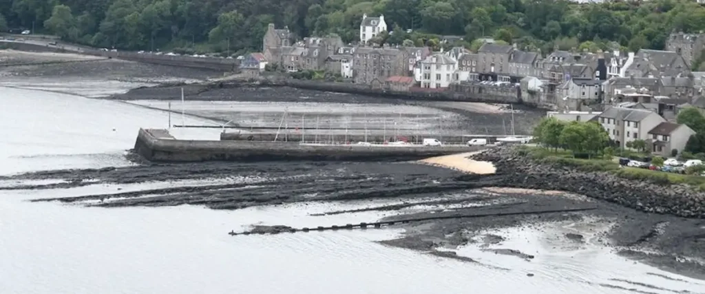
The Binks rocks, later remembered as a landing point, offered one of the few usable shelves where small craft could draw close without grounding. The tidal range dictated approaches: boats had to angle in from the north-east, avoiding deeper channels scoured by the Forth’s currents. This physical constraint likely determined where early travellers came ashore, long before the crossing gained formal status.
Shoreline access shaped settlement patterns. Tracks tended to follow the line of least resistance, skirting marshy pockets and climbing only where the slope broke. Over time, these routes hardened into familiar approaches that later ferrymen and pilgrims would recognise. The location of the eventual Priory was no accident — it sat close to the only predictable point where land met water safely.
How the Forth Shaped Early Life
The Forth acted as both barrier and conduit. Its breadth at Queensferry demanded some form of engineered or semi-regular passage, yet its shifting winds made each crossing uncertain. Those moving north or south had little choice but to negotiate it, which ensured even the earliest hamlet here occupied a strategic position disproportionate to its size.
The estuary also drew people into contact with cultures further east. Trading ports dotted the coast, their existence showing how maritime links predated the town by centuries. The same water routes that carried hides and timber carried ideas and rumours of political upheaval further south – the kind of intelligence that would have reached Malcolm’s court in Dunfermline well before Margaret’s arrival.
Local life was defined by rhythm rather than privilege. Fishing, shore gathering and tending rough plots provided subsistence long before any organised ferry existed. But the need to get people across the Forth ensured a serviceable boat was always part of the settlement’s fabric, even if rudimentary and seasonal.
What the Records Show
Accounts in later burgh documents describe the settlement before 1300 as a small group of thatched structures near the Priory site, a “huddle of hovels” bordered by uncultivated ground to the south and the Forth to the north. These notes, though recorded centuries after the fact, align with what can be inferred from the geography.
The presence of an established trackway running east–west along the shore is implied by references to early trade with northern Europe. Vessels too large to approach the rocks would lie off in deeper water while smaller craft shuttled goods ashore. This pattern of movement likely pre-dated Margaret’s arrival by generations.
Estate papers relating to Dalmeny and Abercorn show religious foundations existed nearby before the 11th century, rooted in earlier settlements influenced by both Celtic and Anglo-Saxon traditions. These records indicate the district already held strategic worth as a meeting point of cultures, making it a natural stage for Margaret’s story to unfold.
Regional and National Influences
Margaret’s journey north in 1067 occurred in the immediate aftermath of the Norman takeover. Refugees fleeing William’s consolidation of power were already moving through Northumbria, and the Forth marked a psychological as well as physical boundary. Malcolm’s court at Dunfermline provided the nearest stable refuge for those dispossessed.
The political tension sharpened the importance of a dependable crossing. A party of rank – even one travelling in distress – needed predictable routes, safe landfall and swift onward travel. The choice of Queensferry’s shoreline reflects what paths were considered workable, not just convenient, in an unsettled time.
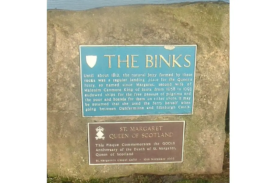
Later burgh tradition held that Margaret’s landing marked the moment the crossing gained its royal association. Whether the Queen stepped ashore exactly at the Binks or nearby matters less than the fact local memory preserved the link – suggesting the arrival was significant enough to fix itself within the community’s identity.
Landownership and Local Authority
The district was under the influence of the early Dundas line and, later, Dunfermline Abbey’s authority. Even before formal charters, control of landing spaces and access tracks fell under local lairds. Disputes recorded centuries later about rights at the Binks indicate a long-standing sensitivity around who regulated the passage and profited from it.
The arrival of a royal party would not have passed unnoticed by those landholders. An event that required hospitality, escort or oversight would reinforce local obligations and privileges. These dynamics foreshadowed later grants, including the eventual establishment of a free passage for pilgrims authorised by Malcolm. The seeds of formal jurisdiction lay in moments like these.
Archival references to early ecclesiastical foundations at Dalmeny and further west show that church interests also shaped the governance of movement. Any crossing that aided pilgrimage northwards strengthened the argument for clerical involvement, which later manifested in charters relating to the Priory.
Social Structure and Community Life
In the 11th century, the settlement’s population likely comprised fishers, smallholders and occasional travellers using the shore track. Subsistence living shaped social rhythms. Houses built from turf and timber clustered tight against the slope, offering some shelter from the northerlies blowing across the Forth. Conditions were stark, but the location ensured passing news and goods reached even this remote edge.
Margaret’s arrival would have been an interruption of rare scale — unfamiliar accents, a distressed noble household and the urgency of political flight. Such an event would have carried into local memory not because of ceremony but because disruptions of this magnitude were uncommon. Over time this recollection hardened into tradition, colouring how the town explained its own origins.
The granting of a free ferry passage later in Malcolm’s reign formalised a pattern that had existed informally: people here already moved strangers across the water for necessity, barter or obligation. The Queen’s association provided legitimacy, anchoring the ferry’s identity in royal initiative even though its real roots lay in earlier routine.
Traces in the Modern Town
Although later construction reshaped the shoreline, the topography still hints at the original landing conditions. The Binks remain visible as rock shelves exposed at lower tides, and the narrowness of the gap between street and shore recalls the early settlement’s tight footprint. These features connect modern visitors to the geography that shaped the first recorded arrival.
Cultural memory also survives in place names and references embedded in older texts. Mentions of the Queen disembarking and the subsequent naming of the ferry link the town’s identity directly to the 1067 landing. Even as buildings evolved from turf to stone, these stories stayed rooted, helping the community maintain continuity through centuries of upheaval.
The Priory Church site, though later rebuilt and repurposed, echoes its long religious lineage. Its position near the most reliable landing ground reinforces how geography and belief intertwined early, creating a focal point around which settlement gradually stabilised.
How This Shaped the Ferry Town
Margaret’s landing catalysed change not because it transformed the settlement overnight, but because it aligned existing practice with royal sanction. A crossing already used out of necessity gained formal recognition, placing Queensferry on a map of movement that mattered politically, religiously and commercially.
The Queen’s later influence at court ensured continued support for the passage, especially for pilgrims travelling to St Andrews. This drew more predictable traffic to the shoreline, which encouraged gradual improvements in infrastructure and settlement density. The ferry became the spine around which the town grew.
In the long term, the association with Margaret provided a narrative anchor. As the settlement evolved into a burgh and later a Royal Burgh, the story of the Queen’s journey offered a legitimising origin point — a reminder that the town’s fortunes were tied to wider national events as much as to its own geography.
Closing Paragraph
The events of 1067 (a year after the Battle of Hastings) mattered because they formalised a crossing long shaped by tide, terrain and necessity. Margaret’s landing gave the place a name, a role and a direction of travel. The next chapter follows how religious foundations, particularly the Carmelite Priory, consolidated this identity and carried the settlement into a more structured medieval life.
Queensferry History Companion (Chapters)

A chapter-by-chapter historical reference
- Chapter 1 – Before Queensferry
- Chapter 2 – Early Crossings
- Chapter 3 – The Making of a Medieval Settlement
- Chapter 4 – Burgh Rights
- Chapter 5 –Turbulent Times
- Chapter 6 – 1700s Prosperity
- Chapter 7 – The Industrial Rise of The Ferry
- Chapter 8 – Steam, Railways, the Coming of the Bridges
- Chapter 9 – Queensferry in Wartime
- Chapter 10 – Modern Queensferry
Hero image: Oliver Dixon, CC BY-SA 2.0, via Wikimedia Commons.
Binks photo: Stanley Howe, CC BY-SA 2.0, via Wikimedia Commons.